Additional Guidance Regarding the Provisions of the Introduction and Part I-A (Part IB)
Chapter summary:
There is important additional guidance to Chapters 1, 2, 3, 6, 8, 9, 10 and 11. There is also detailed additional guidance for important definitions under the Polar Code such as the Mean Daily High Temperature, the Mean Daily Average Temperature, and the Mean Daily Low Temperature. For the full text of Part I B Additional Guidance, see below.
Submissions
Hyperlink: https://iho.int/uploads/user/Inter-Regional%20Coordination/RHC/ARHC/MISC/Notice%20on%20caution%20required%20when%20using%20nautical%20charts%20in%20Arctic%20waters3.pdf
Caution required when using nautical charts of Arctic waters. "As members or associate members of the Arctic Regional Hydrographic Commission (ARHC) and as Member States of the International Hydrographic Organization (IHO), the government Hydrographic Offices of Canada, Denmark, Finland, Iceland, Norway, the Russian Federation, and the United States of America wish to highlight the significant limitations and risks associated with marine navigation in the Arctic."
Hyperlink: http://eloka-arctic.org/
The link submitted is the electronic version of "The Northern Bering Sea: Our Way of Life", published by the Bering Sea Elders Group an alliance of thirty-nine Yup’ik and Inupiaq villages that seeks to protect the sensitive ecosystem of the Bering Sea, the subsistence lifestyle, and the sustainable communities that depend on it. The Northern Bering Sea: Our Way of Life highlights large hunting and fishing areas, and the ecological importance of the region.
The maps and information contained in the submission provide valuable information on locations and timing of marine mammal concentrations and marine mammal migratory routes. Information is also provided on locations and timing of subsistence hunting of marine mammals, an important cultural practice for the region.
Hyperlink: Guidelines for the Development of a Polar Water Operational Manual
The International Chamber for Shipping (ICS) and the Oil Companies International Marine Forum (OCIMF) jointly published this document in 2019. ICS and OCIMF members consider that how a ship is operated in Polar waters, and especially in ice, is a critical aspect for safe operations. The quality of the PWOM will have an impact on achieving safe operations. This document suplements the Polar Code and its Appendix II, which provides a model for a PWOM. The document states that while Appendix II is a useful starting point, ICS and OCIMF members have found that additional information is needed to develop a quality PWOM.
Hyperlink 1: Guidelines for the Development of a Polar Water Operational Manual
Oil Companies International Marine Forum (OCIMF) and the International Chamber for Shipping (ICS) and the jointly published this document in 2019. ICS and OCIMF members consider that how a ship is operated in Polar waters, and especially in ice, is a critical aspect for safe operations. The quality of the PWOM will have an impact on achieving safe operations. This document suplements the Polar Code and its Appendix II, which provides a model for a PWOM. The document states that while Appendix II is a useful starting point, ICS and OCIMF members have found that additional information is needed to develop a quality PWOM.
Hyperlink 2: Northern Sea Route – Best practices and Challenges (2017)
For Part IB, see pages 1 and 12.
Hyperlink 3: Offshore Vessel Operations In Ice and or Severe Sub Zero Temperatures in Artic and Sub Artic regions (2014).
In addition:
- We have also published a book through Witherby Seamanship: The use of large tankers in Seasonal First Year Ice and Severe sub-Zero conditions. (2010), however this has to be purchased this can be purchased for £125 at https://www.witherbyseamanship.com/large-tanker-sub-zero-ice.html
- Other information papers from OCIMF: https://www.ocimf.org/publications/information-papers.aspx#sectionBreadcrumb
The IHO, as an Observer organization at the IMO and its chief advisor on nautical charting issues, has contributed to the safety considerations of the Polar Code, related specifically to the generally unsatisfactory state of the underlying hydrographic surveys from which existing nautical charts in the polar regions are derived.
The IHO input has been based on the work of the two hydrographic Commissions that cover the polar regions - the Arctic Regional Hydrographic Commission (ARHC) and the IHO Hydrographic Commission on Antarctica (HCA). Each Commission provides a framework for cooperation and coordination between the various countries that produce nautical charts of polar waters.
1) IHO Hydrographic Dictionary (IHO Publication S-32)
2) Status of Hydrographic Surveying and Charting Worldwide (IHO Publication C-55) (5 November 2020) (provides base data for governments and supporting international organizations as they consider the best means by which to implement responsibilities set out in Chapter V, Regulation 9, of the Safety of Life at Sea (SOLAS) Convention)
3) Joint IHO/IMO/WMO Manual on Maritime Safety Information (MSI) (IHO Publication No. 53) (January 2016)
4) Facts About Electronic Charts and Carriage Requirements (IHO Publication S-66) (January 2018)
5) The Need for National Hydrographic Services (IHO Publication M-2) (June 2018)
6) Caution Required When Using Nautical Charts of Arctic Waters (ARHC Notice) (28 June 2017)
7) International Bathymetric Chart of the Arctic Ocean (IBCAO) (Version 4.0, July 2020) (The goal of the IBCAO initiative is to develop a digital database that contains all available bathymetric data north of 64° North, for use by mapmakers, researchers, institutions, and others whose work requires a detailed and accurate knowledge of the depth and the shape of the Arctic seabed.)
8) Mariners' Guide to Accuracy of Depth Information in Electronic Navigational Charts (ENC) (IHO S-67) (October 2020)
Guidance on Surveys:
- Note IMO Circular 16 December 2016 (MSC.1/Circ.1562)
Guidance on methodologies for assessing operational capabilities and limitations in ice
- Note IMO Circular 6 June 2016 (MSC.1/Circ.1519)
Interim guidelines on life-saving appliances and arrangements for ships operating in polar waters.
- Note IMO Circular 26 June 2019 (MSC.1/Circ.1614)
Hyperlink: http://arcg.is/1SOnqb
The National Geospatial-Intelligence Agency’s Arctic Support Web map provides public access to nautical information products relevant for the Polar Code including Arctic charts and sailing directions. These standard nautical products address sections 9.2.1 of Chapter 9: Safety of Navigation and 11.3 of Chapter 11: Voyage Planning. The Web map also provides relevant Arctic spatial data for download such as elevation, sea ice extents, airfields, and search and rescue zones. Many other hydrographic and broader maritime domain data sets and resources are provided as Web services.
NGA website
Hyperlink: https://wmo.int
WMO provides information for integrating weather, climate and hydrological data, environmental information and weather-climate predictive tools in the Arctic region, for example through its World Weather Watch (WWW), the Marine Meteorology and Oceanography Programme (MMOP), the Global Cryosphere Watch and other components of the WMO Integrated Global Observing System (WIGOS), WMO Information System (WIS), and WMO Integrated Processing and Prediction System (WIPPS), as well as its World Climate and Weather Research Programmes (WCRP and WWRP). This is the general link to the WMO's public website.
WMO website
PART I-B: ADDITIONAL GUIDANCE REGARDING THE PROVISIONS OF THE INTRODUCTION AND PART I-A: Full Polar Code text
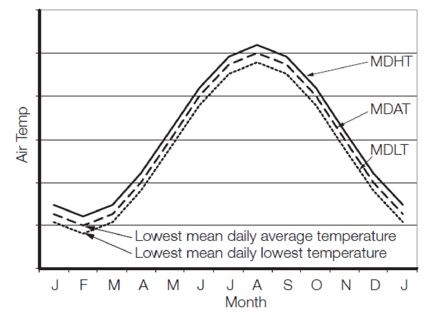
Definitions used in the figure above
MDHT – Mean Daily High Temperature
MDAT – Mean Daily Average Temperature
MDLT – Mean Daily Low Temperature
Guidance instructions for determining MDLT:
- Determine the daily low temperature for each day for a 10 year period.
- Determine the average of the values over the 10 year period for each day.
- Plot the daily averages over the year.
- Take the lowest of the averages for the season of operation.
- 1 - Limitations for operating in ice
- 1.1 Limitations for operation in ice can be determined using systems, tools or analysis that evaluate the risks posed by the anticipated ice conditions to the ship, taking into account factors such as its ice class, seasonal changing of ice strength, icebreaker support, ice type, thickness and concentration. The ship's structural capacity to resist ice load and the ship's planned operations should be considered. The limitations should be incorporated into an ice operational decision support system.
- 1.2 Limitations for operating in ice should be determined using an appropriate methodology, such methodologies exist, have been in use for a number of years and have been validated with service experience. Existing methodologies and other systems may be acceptable to the Administration.
- 1.3 Operation in ice should take into account any operational limitations of the ship; extended information on the ice operational methodology contained in the PWOM; the condition of the ship and ship's systems, historical weather/ice data and weather/ice forecasts for the intended area of operation, current conditions including visual ice observations, sea state, visibility and the judgment of qualified personnel.
- 2 - Operational assessment
- 2.1 - This guidance is intended to support shipowners carrying out, and Administrations reviewing, the assessment required in part I-A, section 1.5, for operational limitations and procedures for the Polar Ship Certificate.
- 2.2 Steps for an operational assessment:
- identify relevant hazards from section 3 of the Introduction and other hazards based on a review of the intended operations;
- develop a model to analyse risks considering:
- development of accident scenarios;
- probability of events in each accident scenario; and
- consequence of end states in each scenario
- assess risks and determine acceptability:
- estimate risk levels in accordance with the selected modelling approach; and
- assess whether risk levels are acceptable; and
- in the event that risk levels determined in steps 1 to 3 are considered to be too high, identify current or develop new risk control options that aim to achieve one or more of the following:
- reduce the frequency of failures through better design, procedures, training, etc.;
- mitigate the effect of failures in order to prevent accidents;
- limit the circumstances in which failures may occur; or
- mitigate consequences of accidents; and
- incorporate risk control options for design, procedures, training and limitations, as applicable.
- 3 - Performance standards
A system previously accepted based on manufacturer certifications, classification society certifications and/or satisfactory service of existing systems may be acceptable for installation on new and existing ships if no performance or testing standards are accepted by the Organization.
- 3.1 Recommendation on the content of the Polar Water Operational Manual The Polar Water Operational Manual (PWOM) is intended to address all aspects of operations addressed by chapter 2 of part I-A. When appropriate information, procedures or plans exist elsewhere in a ship's documentation, the PWOM itself does not need to replicate this material, but may instead cross-reference the relevant reference document. A model Table of Contents is found in appendix 2. The model follows the general structure of chapter 2. Not every section outlined below will be applicable to every polar ship. Many category C ships that undertake occasional or limit polar voyages will not need to have procedures for situations with a very low probability of occurrence. However, it may still be advisable to retain a common structure for the PWOM as a reminder that if assumptions change then the contents of the manual may also need to be updated. Noting an aspect as "not applicable" also indicates to the Administration that this aspect has been considered and not merely omitted.
- 3.2 Guidance on navigation with icebreaker assistance With respect to navigation with icebreaker assistance, the following should be considered:
-
- while approaching the starting point of the ice convoy to follow an icebreaker/icebreakers or in the case of escorting by icebreaker of one ship to the point of meeting with the icebreaker, ships should establish radio communication on the VHF channel 16 and act in compliance with the icebreaker's instructions;
- the icebreaker rendering the icebreaker assistance of ship ice convoy should command ships in the ice convoy;
- position of a ship in the ice convoy should be determined by the icebreaker rendering the assistance;
- ship within the ice convoy, in accordance with the instructions of the icebreaker rendering the assistance, should establish communication with the icebreaker by VHF channel indicated by the icebreaker;
- the ship, while navigating in the ice convoy, should ensure compliance with the instructions of the icebreaker;
- position in the ice convoy, speed and distance to a ship ahead should be as instructed by the icebreaker;
- the ship should immediately notify the icebreaker of any difficulties to maintain the position within the ice convoy, speed and/or distance to any other ship in the ice convoy; and
- the ship should immediately report to the icebreaker of any damage.
- 3.3 Guidance on the development of contingency plans In developing the ship's contingency plans ships should consider damage control measures arrangements for emergency transfer of liquids and access to tanks and spaces during salvage operations. See also additional guidance to chapter 9.
Method for determining equivalent ice class
- The guidance presented below is intended to assist in determining equivalency with standards acceptable to the Organization, as referenced in chapters 3 and 6 of the Code. The methodology is consistent with guidance developed by the Organization while allowing for the use of a simplified approach.
- The basic approach for considering equivalency for categories A and B ships can be the same for both new and existing ships. It involves comparing other ice classes to the IACS Polar Classes. For ice classes under category C, additional information on comparisons of strengthening levels is available for the guidance of owners and Administrations. The responsibility for generating the equivalency request and supporting information required should rest with the owner/operator. Review/approval of any equivalency request should be undertaken by the flag State Administration, or by a recognized organization acting on its behalf under the provisions of the Code for Recognized Organizations (RO Code). Several classification societies have developed easy-to-use tools for determination of compliance with the IACS Polar Class structural requirements, as have some Administrations and other third parties.
- The scope of a simplified equivalency assessment (referring to paragraphs 6.1 to 6.3 below) is expected to be limited to materials selection, structural strength of the hull and propulsion machinery.
- If there is not full and direct compliance, then an equivalent level of risk can be accepted in accordance with guidance provided by the Organization. An increase in the probability of an event can be balanced by a reduction in its consequences. Alternatively, a reduction in probability could potentially allow acceptance of more serious consequences. Using a hull area example, a local shortfall in strength level or material grade could be accepted if the internal compartment is a void space, for which local damage will not put the overall safety of the ship at risk or lead to any release of pollutants.
- For existing ships, service experience can assist in risk assessment. As an example, for an existing ship with a record of polar ice operations a shortfall in the extent of the ice belt (hull areas) may be acceptable if there is no record of damage to the deficient area; i.e. a ship that would generally meet PC 5 requirements but in limited areas is only PC 7 could still be considered as a category A, PC 5 ship. In all such cases, the ship's documentation should make clear the nature and scope of any deficiencies.
- The process includes the following stages of assessment:
- select the target Polar Class for equivalency;
- compare materials used in the design with minimum requirements under the IACS Polar Class URs; identify any shortfalls; and
- compare strength levels of hull and machinery components design with requirements under the IACS Polar Class URs; quantify levels of compliance.
- Where gaps in compliance are identified in steps 1 to 3, additional steps should be necessary to demonstrate equivalency, as outlined below:
- identify any risk mitigation measures incorporated in the design of the ship (over and above the requirements of the Code and IACS URs);
- where applicable, provide documentation of service experience of existing ships, in conditions relevant to the target ice class for equivalency; and
- undertake an assessment, taking into account information from steps 1 to 5, as applicable, and on the principles outlined in paragraphs 2 to 6 above.
- Documentation provided with an application for equivalency should identify each stage that has been undertaken, and sufficient supporting information to validate assessments.
- Where a ship in categories A or B is provided with an equivalency for ice class by its flag State, this should be noted in its Polar Ship Certificate.
9.1 Sample personal survival equipment
When considering resources to be included with the personal survival equipment, the following should be taken into account:
- Suggested equipment
- Protective clothing (hat, gloves, socks, face and neck protection, etc.)
- Skin protection cream
- Thermal protective aid
- Sunglasses
- Whistle
- Drinking mug
- Penknife
- Polar survival guidance
- Emergency food
- Carrying bag
9.2 Sample group survival equipment
When considering resources to be included in the group survival equipment, the following should be taken into account:
- Suggested equipment
- Shelter – tents or storm shelters or equivalent – sufficient for maximum number of persons
- Thermal protective aids or similar – sufficient for maximum number of persons
- Sleeping bags – sufficient for at least one between two persons
- Foam sleeping mats or similar – sufficient for at least one between two persons
- Shovels – at least 2
- Sanitation (e.g. toilet paper)
- Stove and fuel – sufficient for maximum number of persons ashore and maximum anticipated time of rescue
- Emergency food – sufficient for maximum number of persons ashore and maximum anticipated time of rescue
- Flashlights – one per shelter
- Waterproof and windproof matches – two boxes per shelter
- Whistle
- Signal mirror
- Water containers & water purification tablets
- Spare set of personal survival equipment
- Group survival equipment container (waterproof and floatable)
- 10.1 Radars equipped with enhanced ice detection capability should be promoted used, in particular, in shallow waters.
- 10.2 As the chart coverage of polar waters in many areas may not currently be adequate for coastal navigation, navigational officers should:
- .1 exercise care to plan and monitor their voyage accordingly, taking due account of the information and guidance in the appropriate nautical publications;
- .2 be familiar with the status of hydrographic surveys and the availability and quality of chart information for the areas in which they intend to operate;
- .3 be aware of potential chart datum discrepancies with GNSS positioning; and
- .4 aim to plan their route through charted areas and well clear of known shoal depths, following established routes whenever possible.
- 10.3 Any deviations from the planned route should be undertaken with particular caution. For example, and when operating on the continental shelf:
- .1 the echo-sounder should be working and monitored to detect any sign of unexpected depth variation, especially when the chart is not based on a full search of the sea floor; and
- .2 independent cross-checking of positioning information (e.g. visual and radar fixing and GNSS) should be undertaken at every opportunity. Mariners should ensure to report to the relevant charting authority (Hydrographic Office) any information that might contribute to improving the nautical charts and publications.
- 10.4 Ships should be fitted with:
- .1 a suitable means to de-ice sufficient conning position windows to provide unimpaired forward and astern vision from conning positions; and
- .2 an efficient means of clearing melted ice, freezing rain, snow, mist and spray from outside and accumulated condensation from inside. A mechanical means to clear moisture from the outside face of a window should have operating mechanisms protected from freezing or the accumulation of ice that would impair effective operation.
11.1 Limitations of communication systems in high latitude
- 11.1.1 Current maritime digital communication systems were not designed to cover Polar waters.
- 11.1.2 VHF is still largely used for communication at sea, but only over short distances (line of sight) and normally only for voice communication. HF and MF are also used for emergency situations. Digital VHF, mobile phone systems and other types of wireless technology offer enough digital capacity for many maritime applications, but only to ships within sight of shore-based stations, and are, therefore, not generally available in polar waters. AIS could also be used for low data-rate communication, but there are very few base stations, and the satellite-based AIS system is designed for data reception only.
- 11.1.3 The theoretical limit of coverage for GEO systems is 81.3° north or south, but instability and signal dropouts can occur at latitudes as low as 70° north or south under certain conditions. Many factors influence the quality of service offered by GEO systems, and they have different effects depending on the system design.
- 11.1.4 Non-GMDSS systems may be available and may be effective for communication in polar waters.
11.2 Advice for the operation of multiple alerting and communication devices in the event of an incident
A procedure should be developed to ensure that when survival craft are in close proximity, not more than two alerting or locating devices are activated (as required by regulation 10.3.2) at the same time. This is to:
- .1 preserve battery life;
- .2 enable extended periods of time for the transmission of alerting or locating signals; and
- .3 avoid potential interference.
11.3 For satellite distress beacons, although multiple beacon transmissions can be detected successfully by the satellite system, it is not recommended to activate multiple beacons, unless the survival craft operating the beacons are widely dispersed, as this can cause interference on direction-finding equipment.
11.4 Advice on location and communication equipment to be carried by rescue boats and survival craft
In determining the equipment to be carried for transmitting signals for location, the capabilities of the search and rescue resources likely to respond should be borne in mind. Responding ships and aircraft may not be able to home to 406/121.5 MHz, in which case other locating devices (e.g. AIS-SART) should be considered.
In developing and executing a voyage plan ships should consider the following:
- .1 in the event that marine mammals are encountered, any existing best practices should be considered to minimize unnecessary disturbance; and
- .2 planning to minimize the impact of the ship's voyage where ships are trafficking near areas of cultural heritage and cultural significance.
See also additional guidance to chapter 9.