Chapter 11: Voyage Planning (Part IA)
Chapter summary:
This chapter is designed to ensure that the company, master, and crew are provided with sufficient information to enable operations to be conducted with due consideration to the safety of ships and persons on board and, as appropriate, environmental protection. These considerations need to be referenced in the Polar Waters Operational Manual. By way of example, they include but are not limited to Notices to Mariners that are ordinarily contained in government publications. These are set out in the text of Chapter 11 below, and in the Part 1B Additional Guidance.
Following amendments adopted under IMO Resolution MSC.538(107), a new Chapter 11-1 entered into force on 1 January 2026, extending mandatory voyage planning requirements to certain non-SOLAS vessels operating in polar waters. Routes for these vessels through polar waters must account for factors including available hydrographic information, current and historic ice conditions, places of refuge, marine mammal encounter procedures, designated protected areas, and proximity to search and rescue capabilities.
Submissions
Hyperlink: https://ak.audubon.axds.co/
This comprehensive, trans-boundary atlas contains over 100 maps of Arctic marine mammals, seabirds, sea ice, subsistence, and more. The Atlas is organized into six sections that build, layer by layer, the ecological foundation of the Bering, Chukchi, and Beaufort seas.
The six sections are:
- Physical Setting explores various climatic attributes and the abiotic processes that perpetuate them.
- Biological Setting introduces the lower trophic food web.
- Fishes describes a range of prominent pelagic and demersal fish species.
- Birds highlights a long list of seabirds and waterbirds that regularly use these waters.
- Mammals maps out regional use by many cetaceans, pinnipeds, and polar bears.
- Human Uses covers subsistence, conservation, and economic drivers in the region.
Using these data layers it is possible to construct maps that will show areas of likely interaction between vessel traffic and a variety of Arctic marine life and Indigenous subsistence activities.
Chadux̂ is a non-profit organization governed by industry representatives and funded by participating vessel owner/operators that provides vessels operating in Western Alaska and the U.S. Arctic with best management practices and response capabilities. The Network has over 450 vessel companies from around the world representing over 3,500 vessels enrolled in its programs.
Chadux̂ has adopted routing measures for cargo, passenger vessels and yachts as well as for fishing, towing and supply vessels. Conformance with these routing measures results in vessels operating further off shore. In addition, participating vessels are monitored 24/7 while in the U.S. Arctic. This allows for prompt notification of propulsion or navigation issues that require prompt attention to reduce the likelihood of a grounding and pollution event. Decisions related to Ports of Refuge are managed pursuant to Appendix O of the Federal / State of Alaska Unified Response Plan. For information on enrolling in the Chadux̂ and to learn more about risk reducing routing measures in the U.S. Arctic click here.
Hyperlink: Eagle.org
ABS is a leading international classification organization devoted to promoting the security of life and property and preserving the natural environment through the development and verification of standards for the design, construction and operational maintenance of marine and offshore assets.
A critical element of voyage planning is having access to details of the historical temporal environmental conditions in the planned area of operation that may influence the risk associated with operations, including low temperature, the presence of sea ice as it relates to the capability of the ship structure and propulsion train to interact with the ice, the possibility of ice accretion specifically with respect to the presence of environment conditions that facilitate ice accretion and the amount of daylight. ABS Advisory Services offers a climate assessment which included:
- Detailed temperature analysis following the Polar Code’s MDLT. An example of this can be found in Appendix 10 of the ABS Guide for Vessels Operating in Low Temperature Environments (LTE Guide).
- Sea ice analysis using the POLARIS system (MSC.1/Circ.1519). The basis of POLARIS is an evaluation of the risks posed to the ship by ice conditions using the World Meteorological Organization (WMO) nomenclature and the ship’s assigned ice class (or lack thereof). POLARIS can be used for voyage planning or on-board decision-making in real time on the bridge although, as with any methodology, it is not intended to replace an experienced Master’s judgement. POLARIS assesses ice conditions based on a Risk Index Outcome (RIO) determined by the following simple calculation:
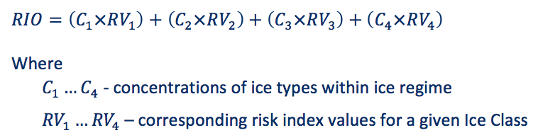
The Risk Values (RV) are a function of ice class, season of operation, and operational state (i.e., independent operation or icebreaker escort). Risk levels are higher with increasing ice thickness and decreasing ice class. POLARIS establishes RVs for the seven (7) IACS Polar Classes, four (4) Finnish-Swedish Ice Classes, and non-ice strengthened ships. For an example a non-ice strengthened, Category C ship, only the bottom row of risk values need to be considered. The row corresponding to the subject vessels will be the bottom row for non-ice strengthened vessels.
ABS-POLARIS is a tool developed by ABS to processes raw ice chart data (sourced from various ice data providers including the Canadian Ice Service, US National Oceanic and Atmospheric Administration, Danish Meteorological Institute, the Russian Arctic and Antarctic Research Institute, etc, using the IMO POLARIS methodology. ABS-POLARIS will determine Risk Index Outcomes and replot ice charts as ice risk charts that are specific to the ship’s ice class notation. The tool can process and plot a single ice chart as an Ice Risk Index Outcome (RIO) chart or process multiple ice charts to evaluate statistical values of RIOs. For example, the ABS-POLARIS tool can take five (5) years of ice charts for a region covering the first week of a month and produce an average RIO for the region. This can be used to evaluate operational probabilities in the given area, or to evaluate the likelihood of the ship encountering ice conditions that exceed its capabilities in that time period. Alternatively, the tool can be used as a means of optimizing the ice class selection if an operational area and time frame is known. Striving for Safer Polar Shipping.
ABS recommends using a multi-year average of RIOs. The ABS-POLARIS averaging algorithm only accounts for areas where ice is present in the average. The figure below graphically shows how the program stacks and calculates the average. If a location only has ice present for a single year the program will only use the year with data in the average. This means that the only ice chart with ice will be the ice shown in the final output. For example, the lower points in the figure where the presence of ice is indicated with a star and circles indicate ice free area. For this five (5) year average the figure will show the RIO from the only year with ice in the area. This results in a slightly conservative ice analysis.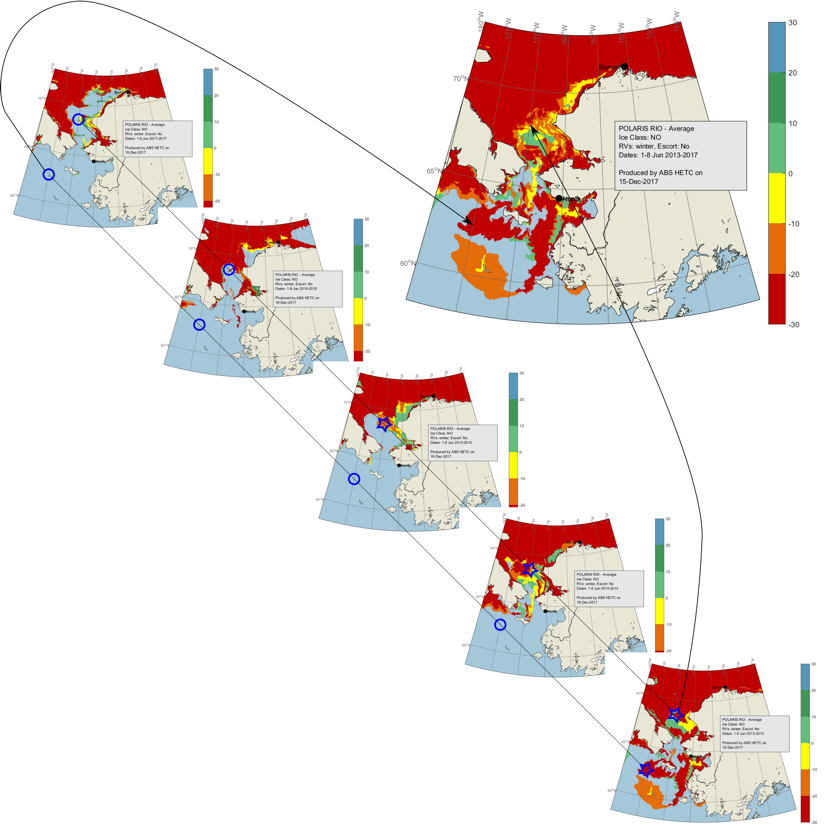
Further examples of the ABS-Polaris outputs can be seen in Figures 12 and 13 of the ABS IMO Polar Code Advisory.
There are aspects of Chapter 11 that can be overlooked by someone developing a Polar Water Operational Manual (PWOM). Most of the regulations of this chapter are not mandatory to be included in the PWOM but ABS suggests that the manual either contain the information required by the regulations of this chapter or make reference to where the crew can access this information.
Hyperlink: www.arcticinfrastructure.org
The Arctic Council's Sustainable Development Working Group approved a project during the Swedish Chairmanship (co-led by the United States and Iceland) to assess transportation infrastructure. The Arctic Marine and Aviation Transportation Infrastructure Initiative (AMATII) seek to evaluate Northern infrastructure ports, airports, and response capability by inventorying maritime and aviation assets in the Arctic.
Hyperlink: http://eloka-arctic.org/
The link submitted is the electronic version of "The Northern Bering Sea: Our Way of Life", published by the Bering Sea Elders Group an alliance of thirty-nine Yup’ik and Inupiaq villages that seeks to protect the sensitive ecosystem of the Bering Sea, the subsistence lifestyle, and the sustainable communities that depend on it. The Northern Bering Sea: Our Way of Life highlights large hunting and fishing areas, and the ecological importance of the region.
The maps and information contained in the submission provide valuable information on locations and timing of marine mammal concentrations and marine mammal migratory routes. Information is also provided on locations and timing of subsistence hunting of marine mammals, an important cultural practice for the region.
Hyperlink 1: Canadian Hydrographic Service / Organization or Service: Arctic Voyage Planning Guide - Canada
https://gisp.dfo-mpo.gc.ca/apps/AVPG-GPNA/
A compilation of data and services relevant to mariners travelling in the Arctic region of Canada. The AVPG is not intended to replace official carriage information or products provided from Canadian sources. In case of disparity, the information contained in official publications will prevail. The mariners remain responsible for navigational decisions and safety of their ships. The information provided in this guide should be used together with all other relevant information, as required by law, standards and good seamanship practices.
Hyperlink 2: Canadian Hydrographic Service / Arctic Regional Hydrographic Commission - https://iho.int/en/arctic-rhc
The IHO has encouraged the establishment of Regional Hydrographic Commissions (RHCs) to coordinate hydrographic activity and cooperation at the regional level. The RHCs are made up of IHO Member States together with other regional States that wish to participate. RHCs work in close harmony with the Organization to help further its ideals and program. RHCs meet at regular intervals to discuss such things as mutual hydrographic and chart production problems, plan joint survey operations, and resolve schemes for medium and large scale International Chart coverage in their regions.
Hyperlink 3: Canadian Hydrographic Service
http://www.charts.gc.ca/
The Canadian Hydrographic Service (CHS) is the hydrographic office of Canada. All vessels in Canadian waters must carry and use nautical charts and related publications pursuant to the Canada Shipping Act, 2001, Charts and Nautical Publications Regulations, that are issued by, or on the authority of, the Canadian Hydrographic Service.
Hyperlink 4: Canadian Hydrographic Service / Northern Canada Sailing Directions
http://www.charts.gc.ca/publications/sailingdirections-instructionsnautiques-eng.asp
Canadian Sailing Directions are companions to nautical charts. Sailing Directions is a great tool for planning and assisting in navigation because they provide information that cannot be shown on a chart.
Hyperlink 5: Canadian Hydrographic Service / Canadian Tide Tables Vol. 4 – Arctic and Hudson Bay.
http://www.tides.gc.ca/eng/data/predictions/2017#vol4
Volume 4 of the CHS Tide tables provides tidal information for CA Arctic waters.
Canadian Hydrographic Service website
Hyperlink: http://ice-glaces.ec.gc.ca/
The Canadian Ice Service's mission is to provide the most timely and accurate information about ice in Canada's navigable waters. We work to promote safe and efficient maritime operations and to help protect Canada's environment.
Hyperlink: https://www.ccamlr.org/en/data/online-gis
The site provides broad scale information on the whole Antarctic Area including daily sea ice concentrations, polar front positions, and a range of management area information from fishing management units to marine protected areas and vulnerable marine ecosystems. Data can be layered onto an Antarctic wide map or viewed layer by layer. As well as the latest extent of sea-ice, it is possible to search for place names and zoom to specific areas.
CCAMLR website
Hyperlink: http://eng.navigation.gl/
Navigation.gl is a portal for use by mariners who are not familiar with navigation in arctic waters, especially the waters surrounding Greenland. Mariners intending to navigate in the waters surrounding Greenland can use the portal to obtain an overview of the websites of relevant authorities and institutions that provide information about safe navigation in these waters. The navigation.gl portal is developed in collaboration between Danish and Greenland authorities. The portal primarily features links to the websites of the Danish Maritime Authority, The Danish Geodata Agency and the Danish Meteorological Institute (DMI).
Danish Geodata Agency
Hyperlink: Guidelines for the Development of a Polar Water Operational Manual
The International Chamber for Shipping (ICS) and the Oil Companies International Marine Forum (OCIMF) jointly published this document in 2019. ICS and OCIMF members consider that how a ship is operated in Polar waters, and especially in ice, is a critical aspect for safe operations. The quality of the PWOM will have an impact on achieving safe operations. This document suplements the Polar Code and its Appendix II, which provides a model for a PWOM. The document states that while Appendix II is a useful starting point, ICS and OCIMF members have found that additional information is needed to develop a quality PWOM
The IHO, as an Observer organization at the IMO and its chief advisor on nautical charting issues, has contributed to the safety considerations of the Polar Code, related specifically to the generally unsatisfactory state of the underlying hydrographic surveys from which existing nautical charts in the polar regions are derived.
The IHO input has been based on the work of the two hydrographic Commissions that cover the polar regions - the Arctic Regional Hydrographic Commission (ARHC) and the IHO Hydrographic Commission on Antarctica (HCA). Each Commission provides a framework for cooperation and coordination between the various countries that produce nautical charts of polar waters.
1) IHO Hydrographic Dictionary (IHO Publication S-32)
2) Status of Hydrographic Surveying and Charting Worldwide (IHO Publication C-55) (5 November 2020) (provides base data for governments and supporting international organizations as they consider the best means by which to implement responsibilities set out in Chapter V, Regulation 9, of the Safety of Life at Sea (SOLAS) Convention)
3) Joint IHO/IMO/WMO Manual on Maritime Safety Information (MSI) (IHO Publication No. 53) (January 2016)
4) Facts About Electronic Charts and Carriage Requirements (IHO Publication S-66) (January 2018)
5) The Need for National Hydrographic Services (IHO Publication M-2) (June 2018)
6) Caution Required When Using Nautical Charts of Arctic Waters (ARHC Notice) (28 June 2017)
7) International Bathymetric Chart of the Arctic Ocean (IBCAO) (Version 4.0, July 2020) (The goal of the IBCAO initiative is to develop a digital database that contains all available bathymetric data north of 64° North, for use by mapmakers, researchers, institutions, and others whose work requires a detailed and accurate knowledge of the depth and the shape of the Arctic seabed.)
8) Mariners' Guide to Accuracy of Depth Information in Electronic Navigational Charts (ENC) (IHO S-67) (October 2020)
Hyperlink: http://nsidc.org/noaa/iicwg/
For Arctic shipping, the website of the International Ice Charting Working Group (IICWG) most importantly provides contact information for all of the national ice services in the world, including 24/7 emergency access to ice information. Additionally, the site provides information about IICWG activities, summaries and presentations from annual IICWG meetings, documents on standards, and links to other ice information sites.
IICWG website
Hyperlink: https://www.navcen.uscg.gov/?pageName=IIPHome
The website of the International Ice Patrol (IIP) is hosted by the United States Coast Guard Navigation Center. The site provides the daily Iceberg Limit to 60°N as a graphical chart, a text bulletin, a KML or a shape file. The graphical chart also contains iceberg distribution estimates. The Iceberg Limit is established by the Canadian Ice Service (CIS) from September through January and by IIP from February through August. A weekly iceberg outlook for the Grand Banks of Newfoundland along with background information describing the IIP’s mission and history are also available on this site. Together with the CIS and the US National Ice Center (USNIC), IIP is a member of the North American Ice Service. The IIP site contains links to CIS and the USNIC.
International Ice Patrol website
Hyperlink: https://www.imo.org/en/MediaCentre/HotTopics/Pages/Polar-default.aspx
IMO's website contains information regarding voyage planning.
Additionally, IMO's Maritime Safety Committee (MSC) in May 2018, adopted new and amended ships' routeing measures in the Bering Sea and Bering Strait, aimed at reducing the risks of incidents - the first measures adopted by IMO for the Arctic region where the Polar Code applies.
The measures include six two-way routes and six precautionary areas, to be voluntary for or all ships of 400 gross tonnage and above, in the Bering Sea and Bering Strait off the coast of the Chukotskiy Peninsula and Alaska, proposed by the Russian Federation and the United States. These waters are expected to see increased traffic due to rising economic activity in the Arctic.
In addition, the MSC established three areas to be avoided in the Bering Sea, proposed by the United States, to improve safety of navigation and protect the fragile and unique environment. These measures entered into force on 1 December 2018.
Further information on IMO Routeing measures
Hyperlink: http://www.paninuittrails.org/index.html?module=module.paninuittrails Chapter 11 voyage planning: The Atlas is one of the outcomes of the project “The Northwest Passage and the construction of Inuit pan-Arctic identities” (funded by SSHRC—the Social Sciences and Humanities Research Council), and co-directed by Claudio Aporta (Marine Affairs Program, Dalhousie University), Michael Bravo (Geography, University of Cambridge), and Fraser Taylor (Geomatics and Cartographic Research Centre, Carleton University). This project looks at Inuit occupancy of the Northwest Passage, through a study and documentation of Inuit traditional trails and place names, which have interconnected Inuit groups across the Arctic since time immemorial.
Marine Affairs website
Hyperlink: https://arctic-nga.opendata.arcgis.com/
The National Geospatial-Intelligence Agency’s Arctic Support Web map provides public access to nautical information products relevant for the Polar Code including Arctic charts and sailing directions. These standard nautical products address sections 9.2.1 of Chapter 9: Safety of Navigation and 11.3 of Chapter 11: Voyage Planning. The Web map also provides relevant Arctic spatial data for download such as elevation, sea ice extents, airfields, and search and rescue zones. Many other hydrographic and broader maritime domain data sets and resources are provided as Web services.
NGA website
Hyperlink 1: https://usicecenter.gov
The USNIC Daily Ice Edge product depicts the daily sea ice pack (8-10/10ths or greater of sea ice), and the Marginal Ice Zone (MIZ). The marginal ice zone is the transition between the open ocean (ice free) and pack ice. The MIZ is very dynamic and affects the air-ocean heat transport, as well as being a significant factor in navigational safety. The daily ice edge is analyzed by sea ice experts using multiple sources of near real time satellite data, derived satellite products, buoy data, weather, and analyst interpretation of current sea ice conditions. The product is a current depiction of the location of the ice edge vice a satellite derived ice edge product.
The USNIC MIZ product is archived by NOAA@NSIDC, from September 2004 for the Arctic and January 2010 for Antarctic ice, available here.
Hyperlink 2: https://nauticalcharts.noaa.gov/publications/coast-pilot/index.html
The United States Coast Pilot® consists of a series of nautical books that cover a variety of information important to navigators of coastal and intracoastal waters and the Great Lakes. Issued in nine volumes, they contain supplemental information that is difficult to portray on a nautical chart. Coast Pilot 9 - 35th Edition, 2017 covers the Pacific and Arctic coasts of Alaska from Cape Spencer to the Beaufort Sea.
Hyperlink 3: https://www.nauticalcharts.noaa.gov/
NOAA’s Office of Coast Survey is the nation’s chartmaker, with over a thousand charts covering 95,000 miles of shoreline and 3.4 million square nautical miles of waters within the U.S. Exclusive Economic Zone.
Hyperlink 4: https://cetsound.noaa.gov/biologically-important-area-map
Chapter 11 of the Polar Code calls for mariners to take into account marine mammals when planning voyages, and to avoid harm as much as possible when transiting in polar environments. In 2011, the U.S. National Oceanic and Atmospheric Administration (NOAA) convened a working group to map cetacean density and distribution within U.S. waters.The specific objective of the Cetacean Density and Distribution Mapping Working Group (CetMap) was to create comprehensive and easily accessible regional cetacean density and distribution maps that are time- and species-specific, ideally using survey data and models, that estimate density using predictive environmental factors.
Hyperlink 5: https://www.pmel.noaa.gov/arctic-zone/data.html
- Realtime Data and Climate Indices
- Data and Analyses
- Indices
- Weather
- Retrospective or Historical Data, Analyses and Indices
- Data and Analyses
-
- Indices
US National Ice Center data products currently archived at NSIDC
At the National Snow and Ice Data Center, selected data originating with NOAA and other operational ice services are archived, and are or will be published online. These have multiyear periods of record. As of September 2021, these data products are archived:
- U.S. National Ice Center. 2020. U.S. National Ice Center Daily Marginal Ice Zone Products, Version 1
- National Ice Center Arctic Sea Ice Charts and Climatologies in Gridded Format
- IMS Daily Northern Hemisphere Snow and Ice Analysis at 1 km, 4 km, and 24 km Resolutions
Other data sets originating with operational ice charting organizations and archived at NSIDC are the following:
- U.S. National Ice Center Arctic and Antarctic Sea Ice Concentration and Climatologies in Gridded Format
- U.S. National Ice Center. Compiled by F. Fetterer and J. S. Stewart. 2020. U.S. National Ice Center Arctic and Antarctic Sea Ice Concentration and Climatologies in Gridded Format, Version 1. [Indicate subset used]. Boulder, Colorado USA. NSIDC: National Snow and Ice Data Center.
- International Ice Patrol Iceberg Sightings Database
- International Ice Patrol. 1995, updated 2020. International Ice Patrol (IIP) Iceberg Sightings Database, Version 1. Boulder, Colorado USA. NSIDC: National Snow and Ice Data Center.
- International Ice Patrol Iceberg Drift Tracks
- National Snow and Ice Data Center (comp.). 1995. International Ice Patrol Iceberg Drift Tracks, Version 1. Boulder, Colorado USA. NSIDC: National Snow and Ice Data Center.
- International Ice Patrol Annual Count of Icebergs South of 48 Degrees North, 1900 to Present
- International Ice Patrol. 2020. International Ice Patrol Annual Count of Icebergs South of 48 Degrees North, 1900 to Present, Version 1.
- Multisensor Analyzed Sea Ice Extent - Northern Hemisphere (MASIE-NH)
- U.S. National Ice Center (NIC) and NSIDC. 2010, updated daily. Multisensor Analyzed Sea Ice Extent - Northern Hemisphere. Developed by F. Fetterer, M. Savoie, S. Helfrich, and P. Clemente-Colón. Boulder, Colorado USA: National Snow and Ice Data Center.
- Canadian Ice Service Arctic Regional Sea Ice Charts in SIGRID-3 Format
- Canadian Ice Service. 2009. Canadian Ice Service Arctic Regional Sea Ice Charts in SIGRID-3 Format, Version 1. Boulder, Colorado USA. NSIDC: National Snow and Ice Data Center.
- Daily Great Lakes Ice Concentration, 1973 Onward
- Great Lakes Environmental Research Laboratory. 2020. Daily Great Lakes Ice Concentration, 1973 Onward, Version 1. Boulder, Colorado USA. NSIDC: National Snow and Ice Data Center.
Hyperlink: http://geodata.npolar.no/barentsportal/?&extent=-1051920,6930390,2322054,9271428&layers=layer6:340
Chapter 11 of the Polar Code calls for mariners to take into account marine mammals when planning voyages, and to avoid harm as much as possible when transiting in polar environments. The Norwegian Polar Institute's Barents Portal provides mariner's with environmental information to ensure as little impact to the marine environment as possible.
Hyperlink: http://www.arcgis.com/home/webmap/viewer.html?webmap=5ceec85326374c9b9b56e935477a7e80&extent=-180,35.3976,180,87.2166
The Draft Nunavut Land Use Plan is a product of extensive consultations that included visiting all 25 Nunavut communities at least twice. After listening to the residents of Nunavut, governments, industry stakeholders and other interested parties including the Dene residents from Northern Manitoba and Saskatchewan, Inuit from Northern Quebec, the Draft Nunavut Land Use Plan provides clear guidance that directs resource use and development in the Nunavut Settlement Area. The Draft Nunavut Land Use Plan provides for protection of Caribou calving and post-calving grounds and critical bird habitat; identifies traditional on ice travel routes with special management tools to protect them, areas of mineral potential, as well as areas with potential for tourism activities. The Draft Plan also provides Nunavummiut a voice in determining the future of development in the Nunavut Settlement Area at the land use planning level.
NSIDC website
Hyperlink: https://www.nautinst.org/resource-library/technical-library/ice.html
This page contains articles which explain the application of the Polar Code with respect to training - Chapter 12 and the obligations and expectations on mariners and their employers. They identify the constructs of the International Standard for Ice Navigators created by the leading professional body for those navigating ships - The Nautical Institute and provide other useful background reading. The articles embody best practice in the consideration of training and qualifications for the area.
Nautical Institute website
Hyperlink: https://oceansnorth.org/en/canada-arctic-marine-atlas/
Reducing impact from shipping on Inuit use and ecologically significant areas in the Canadian Arctic is the intent behind chapter 11 (voyage planning) of the Polar Code. The Oceans North Integrated Arctic Corridors Framework describes route planning which would lead to low impact shipping in this region.
Oceans North Canada website
Hyperlink 1: Guidelines for the Development of a Polar Water Operational Manual
Oil Companies International Marine Forum (OCIMF) and the International Chamber for Shipping (ICS) and the jointly published this document in 2019. ICS and OCIMF members consider that how a ship is operated in Polar waters, and especially in ice, is a critical aspect for safe operations. The quality of the PWOM will have an impact on achieving safe operations. This document suplements the Polar Code and its Appendix II, which provides a model for a PWOM. The document states that while Appendix II is a useful starting point, ICS and OCIMF members have found that additional information is needed to develop a quality PWOM.
Hyperlink 2: Northern Sea Route – Best practices and Challenges (2017)
Hyperlink 3: Offshore Vessel Operations In Ice and or Severe Sub Zero Temperatures in Artic and Sub Artic regions (2014).
The purpose of this paper is to provide guidance to operators and charterers of offshore support vessels employed for use in areas impacted by ice or severe sub-zero temperatures with the aim of encouraging high standards of safety and environmental protection for those operating in Arctic and Sub-Arctic regions.
Hyperlink: http://www.polarview.aq/
The Polar View data page is operated by the British Antarctic Survey with European Space Agency support. This site provides freely available satellite data and automated ice information products for both polar regions. It is highly utilized by mariners in the Southern Ocean, in particular, where there is a current lack of regular ice information from national services.
Hyperlink 1: http://www.aari.ru/odata/_d0015.php?lang=1&mod=0
For ice types Arctic and Antarctic Research Institute (AARI) has current and historical maps of ice types (and coverage) in the Arctic.
Hyperlink 2: https://seaice.uni-bremen.de/sea-ice-concentration/
For historical data on ice coverage, the University of Bremen has a useful site with current and historical data based on passive microwave data (AMSR2). It should be noted that the ice coverage indicated in the maps as “blue” (in false colour) is ice-coverage up to 10%. In a local area, there may be large ice floes, where the coverage can be up to 100%, as well as spots with less than 10% total coverage. It should also be noted that anecdotal evidence suggest that ice coverage is on the conservative side and that ice cover has been found to be more extensive in real operation that indicated on the map of the day.
Hyperlink 3: http://polarportal.dk/en/sea-ice-and-icebergs/sea-ice-thickness-and-volume/
The Polar Portal operated by the Danish Research Institutions provide guidance of ice-thickness in the Arctic.
Hyperlink 4: http://nsidc.org/soac/sea-ice-age-year.html
For historical ice age data, the National Snow and Ice Data Centre operates a useful site where different years and seasons can be compared.
Hyperlink 5: https://worldview.earthdata.nasa.gov
For visual historical observations of ice conditions, Nasa’s Worldview can be sued to select a particular area and time. The webbsite provides a good visual verification if the selected day had limited cloud cover. Ice conditions can be compared to other times/years on the same location. The Polar Portal operated by the Danish Research Institutions provide guidance of ice-thickness in the Arctic.
Swedish Transport Agency website
Hyperlink: https://cgmix.uscg.mil/MARPOL/Default.aspx
The purpose of the Coast Guard Maritime Information Exchange (CGMIX) website is to make Coast Guard maritime information available on the public internet in the form of searchable databases. For Ships Operating in the US Arctic and Near Arctic the CGMIX Public Database includes a link to MARPOL Servicing Facilities.
This online searchable database contains a listing of all U.S. Ports and Terminals holding valid MARPOL Certificates of Adequacy (COAs). Ships operating in the Arctic are subject to additional restrictions relating to discharges of Annex I Oil/Oily residue, Annex II Noxious Liquid Substances, Annex V Garbage including food waste, and Annex VI Ozone Depleting Substances and Stack Scrubber residues. U.S. Ports and Terminals are issued Certificates of Adequacy (COAs) as evidence that their facilities meet the requirements of Annexes I, II, and V of the International Convention for the Prevention of Pollution from Ships (MARPOL).
Adequate port reception facilities (PRF) at Arctic and near Arctic ports and terminals are meant to ensure ships can comply with enhanced restrictions on discharges from ships to the sea outlined in the Polar Code. US MARPOL regulations are further detailed in 33 CFR Part158. https://www.gpo.gov/fdsys/pkg/CFR-2001-title33-vol2/pdf/CFR-2001-title33-vol2-part158.pdf
Additional resources include: -The World Port Index published by the (US) National Geospatial Agency which provides Marine Safety Information on ports and terminals around the world. This publication gives the location, characteristics, known facilities, and available services of a great many ports and shipping facilities and oil terminals throughout the world and can be downloaded as a PDF document. The data is arranged geographically and is keyed to the applicable Volume of the Sailing Directions and shown on a chart. https://msi.nga.mil/Publications/WPI
The IMO's Global Integrated Shipping Information System (GISIS) which includes databases on pollution prevention equipment for ships and MARPOL port reception facilities. The public, searchable databases are arranged by Member States (including all eight Arctic Council states) and provide contact information for ports and terminals including those in Arctic regions. Information on ships waste management in the form of IMO Guidance can be downloaded from the website for ships and PRF operators. The guidance while not specific to Arctic shipping will be useful for ship operators planning on voyaging in Arctic or near Arctic waters. (MEPC.1/Circ.834.Rev.1) in English, French and Spanish. GISIS Data Base: https://gisis.imo.org/Public/Default.aspx
Guidance (Free Download from the GISIS site): https://gisis.imo.org/Public/Shared/Public/Download.aspx?FileType=UnsecuredFile&FileCode=PRF-GUIDE
Hyperlink 1: https://wwmiws.wmo.int/
The Global Maritime Distress and Safety System (GMDSS) website displays the marine forecast and warning products that are provided to mariners via SafetyNet, SafetyCast, and NAVTEX, as part of the Worldwide Met-Ocean Information and Warning Service (WWMIWS), within the framework of the Global Maritime Distress and Safety System (GMDSS). The worlds' oceans have been divided into 21 areas, called METAREA's, for the provision of marine products to shipping. The products displayed are issued by the National Meteorological Services (NMS) appointed as WWMIWS Issuing Services. METAREA Coordinators are assigned to coordinate provision of the marine services for each area. Canada, Norway, Russian Federation have responsibilities in the respective METAREAs in the Arctic polar waters.
Hyperlink 2: https://www.arctic-rcc.org/
Arctic RCC Network and Arctic Climate Forum
Based on the WMO Regional Climate Centre’s (RCCs) concept and as a legacy of the 2007-2008 International Polar Year, the Arctic Regional Climate Centre Network (ArcRCC-Network) has been established in May 2018. The ArcRCC-N is a centre of excellence that links Arctic national meteorological and ice services and provides regional climate products and services. Canada leads the forecasting services, Norway the data services and Russia the monitoring services. Currently Norway provides overall coordination of the Network activities. The Network members committed to provide on a regular basis all the products and services, including climate data, monitoring, long-range forecasting, as defined in the Implementation Plan. The Arctic Climate Forum (ACF) , a flagship activity of the ArcRCC-Network serves as a platform that brings together climate experts and sector representatives from countries, e.g. from indigenous community, shipping, tourism, hunting, ice-breaking, etc., to produce consensus-based climate prediction and information, with input from global and regional producing centres and National Meteorological and Hydrological Services, with the aim of gaining substantial socio-economic benefits in climate sensitive sectors. ACF sessions normally occur every May and October to produce seasonal outlook on temperature, precipitation, sea ice, snow cover for summer and winter season respectively. The ArcRCC-Network coordinates this activity and provides technical input to ACF building on atmospheric, oceanic and ice data sets from observing networks, model outputs, satellites.
Hyperlink 3: https://community.wmo.int/en/activity-areas/Marine/Pubs/WMO-No9-Vol-D-Information-for-Shipping
The WMO No. 9 Volume D: Information for Shipping contains Marine meteorology and other related geophysical information necessary for safe and economic conduct of shipping operations, as well as for fishing and other marine activities, is made available to the user by the various Meteorological Services of maritime countries. The provision of this information is co-ordinated by WMO. The Chapter 4 Part C contains the ship weather routing services.
Hyperlink 4: https://library.wmo.int/index.php?lvl=notice_display&id=12793#.X7aDi2j0n4Q
The Manual on the WMO Integrated Processing and Prediction System (WMO No. 485) is designed to ensure uniformity and standardization of data, information and production practices, procedures and specifications employed among WMO Members in the operation of the WMO Integrated Processing and Prediction System (WIPPS).
Some WIPPS Designated Centres (WIPPS-DC), also referred to as Regional Specialized Meteorological Centres (RSMCs), address general marine meteorological services and marine emergency response (MER) - including support for Search and Rescue (SAR) Operations.
WMO website
Hyperlink 1: http://awsassets.wwf.ca/downloads/hudsonstraitmarinersguide_2.pdf?_ga=2.224626205.640108791.1510171305-2063225585.1506616454 Chapter 11 of the Polar Code calls for voyage planning that results in the least amount of impact on marine mammals in the Arctic. The Hudson Strait Mariner’s Guide is designed to assist with this provisions. The Guide is made up of two large posters to be hung on the ship’s bridge: a chart that will help mariner’s identify whales, seals, polar bears and walrus, and maps of marine mammal habitat in both summer and winter. The guide lists phone numbers so mariners can report sightings and incidents at both the national and community level, and provides operational guidance when close to or encountering marine mammals.
Hyperlink 2: https://www.wwf.dk/wwfs_arbejde/gronland_og_arktis/sadan_arbejder_vi/oget_sejlads_er_en_trussel_mod_hvaler_/ Chapter 11 of the Polar Code calls on mariners to plan voyages with the least amount of impact on marine mammals in the Arctic. The Greenland Mariner's Guide is a tool for mariners to operationalize this chapter in the Code and reduce harm as much as possible on marine life in Greenlandic waters.
Hyperlink 3: http://oceanplanning.wwf.ca
Chapter 11 of the Polar Code requires mariners to plan voyages which results in the least amount of harm to marine life. WWF Arctic Oceans map depicts areas of high value to local communities and makes recommendations on use and protection for the region.
Hyperlink 4: Eastern Arctic Mariner’s Guide
The Eastern Arctic Mariner's Guide is made up of three large posters to be hung on a ship’s bridge, consisting of:
- Visual identification chart that will help mariners recognize whales, seals, polar bears and walruses.
- Maps of critical habitat, migration routes and calving areas.
- Maps indicating designated conservation areas and ice, including community on-ice travel routes and caribou sea-ice crossings.
- Recommends courses of action regarding sensitive whale habitats, walrus habitat, caribou sea-ice crossings, shipping in polynyas and around floe edges, ice-breaking and Inuit travel routes as well as a tourism exclusion zone and travel speed.
- Lists phone numbers so mariners can report sightings and incidents at both the national and community level, and provides operational guidance when close to or encountering marine mammals.
CHAPTER 11 – VOYAGE PLANNING FOR SHIPS CERTIFIED IN ACCORDANCE WITH CHAPTER 1: Full Polar Code text
As adopted from IMO - Full Polar Code text
Ammended by IMO Resolution MSC.538(107) (Entry into force 1 January 2026)
This chapter applies to ships certified in accordance with SOLAS chapter I.
11.1 Goal
The goal of this chapter is to ensure that the Company, master and crew are provided with sufficient information to enable operations to be conducted with due consideration to safety of ship and persons on board and, as appropriate, environmental protection.
11.2 Functional requirement
In order to achieve the goal set out in paragraph 11.1 above, the voyage plan shall take into account the potential hazards of the intended voyage.
11.3 Requirements
In order to comply with the functional requirement of paragraph 11.2 above, the master shall consider a route through polar waters, taking into account the following:
- .1 the procedures required by the PWOM;
- .2 any limitations of the hydrographic information and aids to navigation available;
- .3 current information on the extent and type of ice and icebergs in the vicinity of the intended route;
- .4 statistical information on ice and temperatures from former years;
- .5 places of refuge;
- .6 current information and measures to be taken when marine mammals are encountered relating to known areas with densities of marine mammals, including seasonal migration areas;
- .7 current information on relevant ships' routing systems, speed recommendations and vessel traffic services relating to known areas with densities of marine mammals, including seasonal migration areas;
- .8 national and international designated protected areas along the route; and
- .9 operation in areas remote from search and rescue (SAR) capabilities.
Chapter 11-1
Voyage planning for fishing vessels of 24 metres in length overall and above, pleasure yachts of 300 gross tonnage and upwards not engaged in trade and cargo ships of 300 gross tonnage and upwards but below 500 gross tonnage.
This chapter applies to the following ships operating in polar waters:
- .1 fishing vessels of 24 metres in length overall and above,
- .2 pleasure yachts of 300 gross tonnage and upwards not engaged in
trade; and - .3 cargo ships of 300 gross tonnage and upwards but below 500 gross
tonnage.
11-1.1 Goal
The goal of this chapter is to ensure that the company, master and crew are provided
with sufficient information to enable operations to be conducted with due
consideration to safety of ship and persons on board and, as appropriate,
environmental protection.
11-1.2 Functional requirement
In order to achieve the goal set out in paragraph 11-1.1 above, the voyage plan shall
take into account the potential hazards of the intended voyage.
11-1.3 Requirements
In order to comply with the functional requirement of paragraph 11-1.2 above, the
master shall consider a route through polar waters, taking into account the following:
- .1 the procedures required by the safety management system on board; if no safety management system is implemented there shall be a documented procedure for operation in polar waters;
- .2 any limitations of the hydrographic information and aids to navigation available;
- .3 current information on the extent and type of ice and icebergs in the vicinity of the intended route;
- .4 statistical information on ice and temperatures from former years;
- .5 places of refuge;
- .6 current information and measures to be taken when marine mammals are encountered relating to known areas with densities of marine mammals, including seasonal migration areas;
- .7 current information on relevant ships' routeing systems, speed recommendations and vessel traffic services relating to known areas with densities of marine mammals, including seasonal migration areas;
- .8 national and international designated protected areas along the route; and
- .9 operation in areas remote from search and rescue (SAR) capabilities.