Large Marine Ecosystems
Large Marine Ecosystems (LMEs) are regions of ocean space of 200,000 km² or greater, that encompass coastal areas from river basins and estuaries to the outer margins of a continental shelf or the seaward extent of a predominant coastal current. LMEs are defined by ecological criteria, including bathymetry, hydrography, productivity, and tropically linked populations. The LME concept for ecosystem-based management has 5-module approach focused on productivity, fish and fisheries, pollution and ecosystem health, socioeconomics, and governance.
The EA is embedded in the core of the concept of Large Marine Ecosystems (LMEs) which has been around for about 30 years. The LME process was launched in the early 1980s and has proceeded with a number of symposia and books about the concept, approach, methodological aspects, and conditions in a wide range of LMEs around the globe (Sherman 1994, 2008, Sherman et al. 2004). A number of LME projects have been launched with implementation of the EA to the management of specific LMEs such as the Benguela Current, Yellow Sea, and others (Sherman et al. 2009).
Arctic LME Map
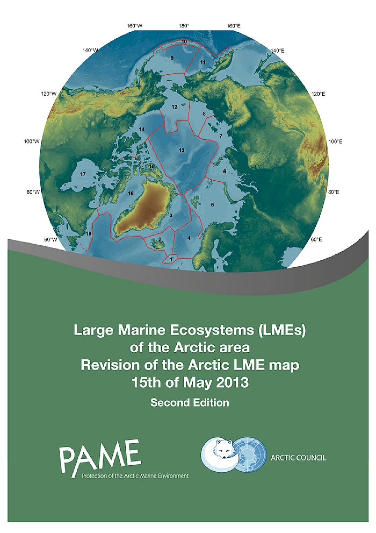
PAME developed a working map delineating 17 Arctic Large Marine Ecosystems (Arctic LME's) in the marine waters of the Arctic and adjacent seas in 2006 The Arctic LMEs were subsequently adopted by Arctic Council. The adoption of the Arctic LMEs acknowledged related work in other forums, in which place-based assessments of the changing states of Arctic LMEs served as the framework for ecosystem-based management practices in the Arctic. The AMAP Oil and Gas Assessment used the 2006 LME map in their work for descriptive purposes to assess impacts of oil and gas activities in the Arctic. Further, the LME concept supports application of the ecosystem approach, EA, to managing human activities that has been promoted within the EU Marine Strategy Framework Directive (MSFD) and OSPAR contexts.
In a consultative process including agencies of Arctic Council member states and other AC work groups, the Arctic LME map was revised during 2012. The revised boundaries of the 18 current LMEs were mapped by the Ecosystem Approach Expert Group (EA-EG) in a report of the consultative process that was subsequently accepted and adopted by the Arctic Council at the ministerial meeting in Kiruna in 2013.
DOWNLOAD LME MAP
The LME Map is available as a data package here.
LME Factsheet Series
PAME has started production of Factsheets for each Arctic LME. The Factsheet-series is intended to better communicate the specifics of each LME. Among information are species overview (mammals, fish and birds), in addition to general information on each LME, such as main features and other relevant information.
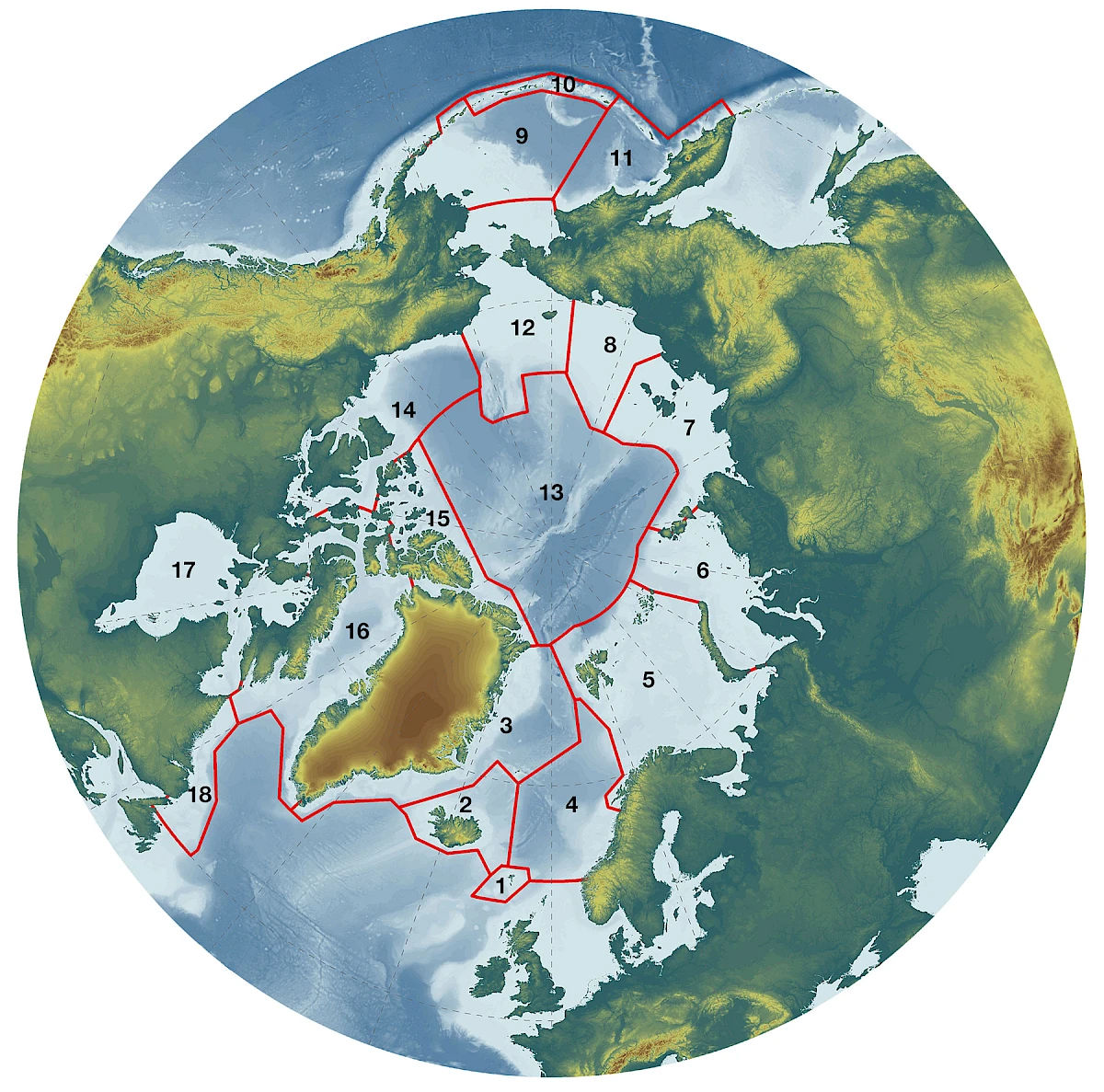
Each factsheet is available to view and download to the right. The numbers correspond to the LME numbers on the map above.
1. Faroe Islands LME
2. Iceland Shelf LME
3. Greenland Sea - East Greenland LME
4. Norwegian Sea LME
5. Barents Sea LME
6. Kara Sea LME
7. Laptev Sea LME
8. East Siberian Sea LME
9 & 11. Bering Sea LME
10. Aleutian Islands LME
12. Northern Bering-Chukchi Sea LME
13. Central Arctic Ocean LME
14. Beaufort Sea LME
15. Canadian High Arctic-North Greenland LME
16. Baffin Bay LME
17. Hudson Bay LME
18. Labrador-Newfoundland LME

The LME Report
PAME's report on LME's from 2013 provides a great understanding of each LME. It also describes the process of identifying LME's and how the need for revisions became apparent when it was observed that boundaries were cutting through important ecological features to split them somewhat arbitrarily in two parts, in the absence of an actual natural ecological or geophysical discontinuity. For example the boundary between the Chukchi and Bering Seas LMEs across the Bering Strait was seen as contradictory to a natural connection between the Chukchi and northern Bering, as was the case for the boundaries between the Laptev, East Siberian and Chukchi Seas LMEs at the New Siberian Islands and Wrangel Island, respectively.