Arctic Marine Tourism

Arctic Marine Tourism
This is the online repository for PAME's Arctic Marine Tourism Project (2019-2021). This project has compiled and analysed information about passenger vessels from 2013-2019. Data has been filtered and organized and presented in the form of this online repository of information, available for use by all. A key component of AMTP 2021, this repository includes a range of detailed Excel sheets as well as accompanying maps that can be further manipulated for desired ends (e.g. trend analysis). 

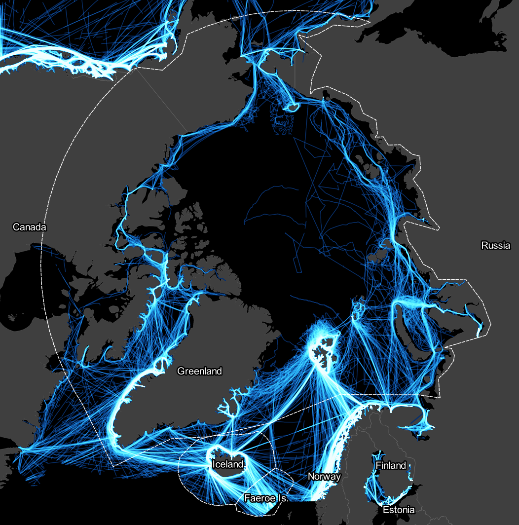
The information is for three areas, the Arctic Polar Code area, the Icelandic EEZ and the Faroe Islands EEZ.

This repository contains:
 - Excel spreadsheets with a list of ships and information on each ship entering the area 2013-2019 (total and monthly aggregated)
 - Maps from the Arctic Marine Tourism 2021 Report, and more maps then contained in the report
 - Graphics from the Arctic Marine Tourism 2021 Report

All information and data is free for use by all.

Please cite PAME: Arctic Marine Tourism Project if information is used.


DOCUMENTS TO BE UPLODADED.

Categories

Data sheets (Excel)

Developed by the British Antarctic Survey.

Documents

Guidelines as management tool in Arctic tourism

By 2155 downloads

Download (pdf, 2.11 MB)

WP 2-Guidelines as management tool in Arctic tourism ver 1.0.pdf

Developed as a part of PAME's Arctic Marine Tourism Project by AECO.

Developing Site Specific Guidelines

By 2998 downloads

Download (pdf, 3.98 MB)

WP 2-Developing Site Specific Guidelines ver 1.0.pdf

Developed as a part of PAME's Arctic Marine Tourism Project by AECO.

GIS Analysis Report - British Antarctic Survey

By 1571 downloads

Download (pdf, 642 KB)

PAME_Arctic_Marine_Tourism_GISAnalysis_BAS_Report_v1.0.pdf

Polar Code Area: Cruise Ships

By 1703 downloads

Download (xlsx, 539 KB)

Polar Code Area - Cruise Ships.xlsx

Polar Code Area: Passenger ships

By 1383 downloads

Download (xlsx, 158 KB)

Polar Code Area - Passenger ships.xlsx

Polar Code Area: Yachts

By 1338 downloads

Download (xlsx, 72 KB)

Polar Code Area - Yachts.xlsx

Faroe Islands: Cruise Ships

By 1559 downloads

Download (xlsx, 158 KB)

Faroe Islands - Cruise Ships.xlsx

Faroe Islands: Passenger Ships

By 1338 downloads

Download (xlsx, 29 KB)

Faroe Islands - Passenger Ships.xlsx

Faroe Islands: Yachts

By 1184 downloads

Download (xlsx, 28 KB)

Faroe Islands - Yachts.xlsx

Iceland: Cruise Ships

By 1425 downloads

Download (xlsx, 178 KB)

Iceland - Cruise Ships.xlsx

Iceland: Passenger Ships

By 1390 downloads

Download (xlsx, 63 KB)

Iceland - Passenger Ships.xlsx

Iceland: Yachts

By 1511 downloads

Download (xlsx, 38 KB)

Iceland - Yachts.xlsx

All ship tracks: 2013

By 1375 downloads

Download (png, 773 KB)

2013_all ships.png

All ship tracks: 2019

By 1341 downloads

Download (png, 986 KB)

2019_all ships.png

Kisaq Ship Tracks: 2019

By 1406 downloads

Download (png, 1012 KB)

6506458_op100.png

MS Bremen Ship Tracks: 2019

By 1399 downloads

Download (png, 1.24 MB)

8907424_MS Bremen_2019.png

All ships 2013-2019

By 1403 downloads

Download (png, 865 KB)

All ships 2013-2019.png

All ships 2013-2019 around Svalbard

By 1365 downloads

Download (png, 1.59 MB)

All ships 2013-2019_Svalbard.png

Tourism Report Analysis Areas

By 1370 downloads

Download (jpg, 705 KB)

Analysis areas.jpg

MSS Meraviglia Ship Tracks (biggest capacity ship): 2018

By 1293 downloads

Download (png, 329 KB)

biggest capacity ship_2018.png

© 2024 PAME. Borgir v. Nordurslod. 600 Akureyri. Iceland. All Rights Reserved.

Please publish modules in offcanvas position.